Navigating the complex network of American roads requires an understanding of the visual language designed to help drivers find their way. Furthermore, guide and service signs are essential components of this language, providing critical information about destinations, directions, and available services without requiring drivers to stop and consult maps or electronic devices.
Guide Signs Driving
Guide signs serve as your roadside map, helping you navigate to your destination with confidence. Generally, these signs are rectangular and come in specific colors that indicate their purpose.
What Color are Guide Signs | Direction and Distance
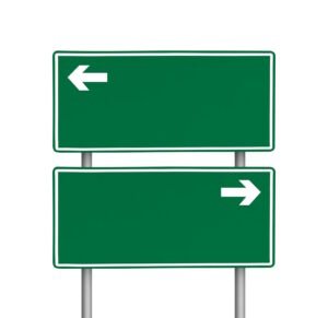
Green rectangular signs with white lettering are among the most common guide signs on American roads. Specifically, they provide directional information, indicating where places are located and how far away they are. Moreover, these signs are your silent navigators, telling you the distance to upcoming cities, indicating which lane leads to your destination, or showing exit numbers on highways.
For instance, as you approach a major interstate junction, green signs will indicate which lanes you should choose based on your destination. Additionally, they often use arrows to make the directions clear and intuitive. Subsequently, they’ll show city names and distances, helping you gauge your progress on long journeys.
Brown Signs Indicate Recreation and Cultural Destinations
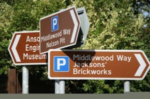
If you’re seeking historical sites, parks, or recreational areas, look for the brown guide signs. In particular, these rectangular markers with white lettering direct travelers to points of interest that aren’t necessarily part of their essential travel needs. However, they enhance your journey by highlighting cultural and recreational opportunities.
While driving through Arizona, for example, brown signs might direct you to the Grand Canyon National Park. Similarly, in Massachusetts, they could guide you to historic Faneuil Hall. Consequently, these signs help preserve America’s cultural heritage by making these locations accessible to travelers.
Blue Traffic Signs | Services for Travelers
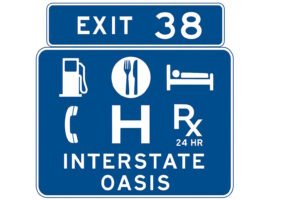
Blue guide signs serve a practical purpose, pointing the way to essential services that travelers might need. Particularly, these rectangular signs with white symbols or lettering direct you to rest areas, hospitals, gas stations, food, lodging, and other traveler services.
Picture yourself driving through an unfamiliar stretch of Interstate 80 in Nebraska. Meanwhile, your gas gauge is dropping, and you’re getting hungry. Fortunately, the blue service signs along the highway might show you that in two miles, you can find gas stations, restaurants, and hotels at the upcoming exit. As a result, this information allows you to plan your stops efficiently without having to exit the highway unnecessarily.
Service Signs: Meeting Your Needs on the Road
Service signs specifically inform drivers about available facilities and services along their route. Notably, these signs are particularly valuable on long stretches of highway where services might be limited.
Rest Area Information

Rest areas provide essential stops for tired drivers, and blue signs with the “REST AREA” text mark their locations. Furthermore, some rest area signs may include additional information about the facilities available. For example, they might indicate whether they have restrooms, picnic areas, or tourist information.
According to the Federal Highway Administration, the strategic placement of rest areas has been shown to reduce fatigue-related accidents on long stretches of highway.
Specific Service Signs (Logo Signs)
![]()
Many highways feature blue signs with the logos of restaurants, gas stations, and hotels available at upcoming exits. Typically, these logo signs appear in advance of exits, giving drivers time to decide whether to stop. Moreover, they may show multiple businesses of the same type at a single exit. Therefore, they help drivers make informed choices about where to stop.
Hospital and Emergency Services

Perhaps the most critical service signs are those directing drivers to emergency services. Specifically, hospital signs, marked with an “H” or the medical cross symbol on a blue background, guide drivers to the nearest medical facilities. Indeed, these can be lifesaving in emergencies, particularly for travelers unfamiliar with the area.
Mile Markers and Reference Points

While not traditional guide signs, mile markers serve an important navigational purpose. Generally, these small green signs appear at one-mile intervals along interstates and highways. Thus, they show the distance from where the route entered the state.
Mile markers help you in several ways. First, they allow you to calculate the distance to your exit or destination. Second, they provide your exact location in case of an emergency. Finally, they serve as reference points when following directions.
As noted in the Iowa Driver’s Manual, “Mile markers can be used to calculate how far you are from your exit or destination and give your exact location in an emergency.”
Reading the Road: The Shape and Color System
The American road sign system uses a consistent color and shape coding that makes signs recognizable even from a distance. Specifically, the system follows these patterns:
Green rectangular signs indicate directions and distances. Meanwhile, blue rectangular signs show traveler services. Additionally, brown rectangular signs point to recreational or cultural sites.
This color-coding system is standardized across the country. Consequently, a blue service sign in Maine indicates the same type of information as one in California. Therefore, this national consistency helps drivers navigate confidently anywhere in the United States.
Route Markers: Knowing Your Road
Route markers are a special type of guide sign that shows the specific highway or road you’re traveling on. Moreover, their shapes indicate the type of roadway:
Interstate highways are marked with a distinctive red and blue shield. In contrast, U.S. highways use a white shield with black numbering. Furthermore, state routes typically use state-specific shapes such as circles or outlines of the state.
During a long road trip, following these route markers helps ensure you stay on your planned route. For instance, if you’re traveling from Chicago to Los Angeles on historic Route 66, you’d follow the U.S. Highway 66 markers along your journey.
Digital Enhancement of Traditional Signs
While physical signs remain the primary navigation tools on American roads, many states are now complementing these with digital enhancements. Particularly, variable message signs provide real-time information about traffic conditions, construction, or emergencies. Moreover, these electronic signs can change their messages as conditions warrant. Thus, they provide up-to-date guidance to travelers.
In areas with heavy tourism, some guide signs now include QR codes that travelers can scan for additional information about destinations. However, these should only be used when the vehicle is stopped.
Finding Your Way Forward
The next time you travel America’s highways, take a moment to appreciate the carefully designed system of guide and service signs. Indeed, these signs help millions of drivers navigate safely every day. Furthermore, these silent sentinels of the road provide critical information exactly when you need it. Consequently, they guide you to your destination while helping you find essential services along the way.
Understanding this visual language of the road not only makes your journeys more efficient but also safer. As a result, you can focus more attention on driving and less on figuring out where you are and where you’re going. From the green directional signs pointing you toward major cities to the blue service signs helping you find a place to rest, America’s guide and service signs truly keep the nation moving forward.